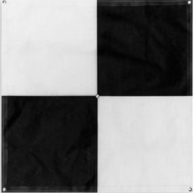
More often than not, in geospatial analysis and mapping, every inch counts. Whether in land surveying, or monitoring the impact of the environment in a certain area, data collected has a huge impact. This is where Ground Control Points or GCPs come into action. These clues on the Earth’s surface are used to orient, standardize, or check the mapping information. Such as from aerial or satellite photos. Correct approaches towards setting GCPs and field surveys can yield high improvement in map precision. Good application of the GCP field survey methods guarantee that your mapping outcomes are correct and very precise.
The Importance of GCPs in Mapping
GCPs are poly points that act as surveying reference points to control the image overlay of remotely sensed images, such as aerial photography or drone imagery. These reference points are placed in known positions by surveyors to correct distortions or misalignments within the mapping data. By accurately placing these points, the mapped features can be adjusted to closely resemble the actual areas on Earth, ensuring precision in the final map. This process is essential for improving the accuracy of geospatial data in various applications.
The deployment of GCPs is especially significant. As it provides a level of precision essential to infrastructure, the environment, or archaeology projects. The distortion or error that may occur when using the advanced mapping technology is limiting. It is usually because of the inadequate positioning relative to the GCPs. Hence, knowledge of GCP field survey is an essential procedure. It is important for anyone engaged in geospatial data acquisition and mapping.
Planning the GCP Survey
The starting point for any GCP survey is to ensure that the right amount of planning has been done. Thus, it is recommended to study a certain degree of the geographic area. Also the specialties of the mapping project in advance of going into the field. This assists in the determination of how many Ground Control Points are needed and where to establish them.
As much as possible, the density of GCPs should match that of the survey area. So to get good spared coverage. The use of figures with subjects put at different heights also enhances mode correction. Because it eliminates errors contributed by height differences in the landscape. Besides, it would be relevant to select areas that are not likely to undergo certain changes during the period of the survey. Big structures, buildings, or other similar, can have permanent or even semi-permanent GCP markers.
In the planning stage, satellite images or even drone maps should be used to help in selecting possible GCP areas. That will be taken beforehand of the real survey. This can save a lot of time.
Fieldwork: Laying Out the GCPs
If the planning phase is accomplished then the next process is to geo-reference the currently identified GCPs. These points have to be positioned accurately and easily recognizable. For this reason, GCPs should be painted in bold and clear colors, big targets, or highly contrasting colors than other markers. This is important on the ground to make them easily recognizable from aerial/satellite photographs.
It is recommended when designing a GCP to use either a high-accuracy GPS receiver. Or a total station to pinpoint the position of each point. This enables the acquisition of accurate coordinates of the GCPs. It is useful for minimizing or preventing even the slightest errors. When all points are to be marked out then it becomes essential to record all these points in detail. This should also involve writing down coordinates of other important features around the point. In case one wants to re-establish the GCPs in the future.
Post-Processing and Data Correction
Once the locations of the GCPs have been determined and established, then comes the post-survey analysis. This involves the application of GCPs to re-adjust and geo-reference the aerial image or other RS data set. Post-processing software, for example through Pix4D, the user can input the GCP coordinates. And then correct the image or map to be aligned with those coordinates.
This step is very important because confusing one GCP with another or placing an incorrect coordinate on any one GCP can systematically degrade the final map product. Correction of such errors and confirmation that the GCPs are well positioned is important. As it makes it possible for surveyors to develop maps that have fairly good levels of positional accuracy. This process can take some time, especially if the project in question is complex. But it is vital in developing quality geospatial information.
Conclusion
GCPs are a basic instrument for achieving accurate and reliable mapping results. With proper planning of the GCP coordinate, surveyors can be able to map their projects properly. And have them well aligned to the real-world points of coordination. Proper marking of their location, and correct processing of the data is also an important factor. So, the proper field survey techniques are pivotal in GCP surveys to ensure the least errors are committed. And excellent quality maps are generated that can be relied on across various professions.
Delivering GCPs into an area is undoubtedly a basic though crucial stage. Especially towards the quality control of mapping exercises in small-scale surveys or large projects. Such as infrastructure developments etc. As technology progresses and the need for mapping increases GCPs will always be useful for people in this field.
For more information click here


